- Geographical enquiry
- Fieldwork
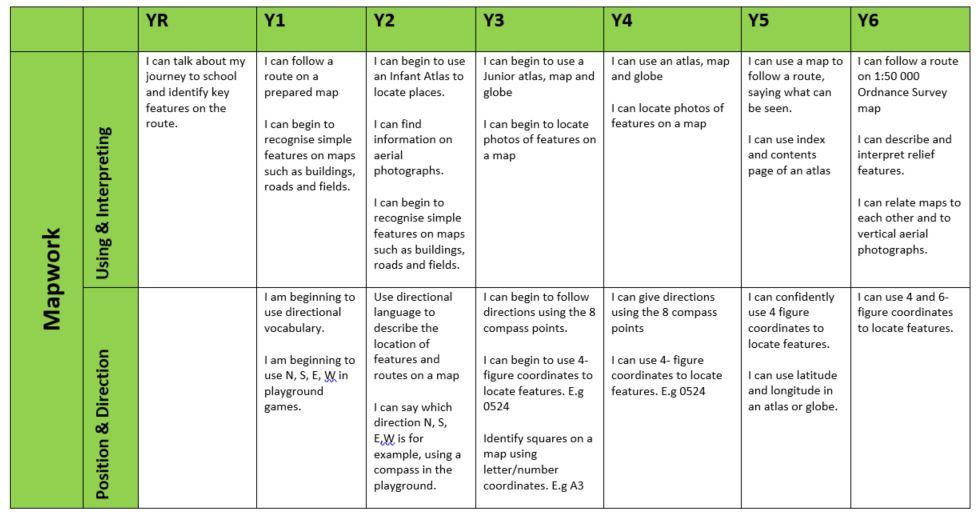
- Mapwork
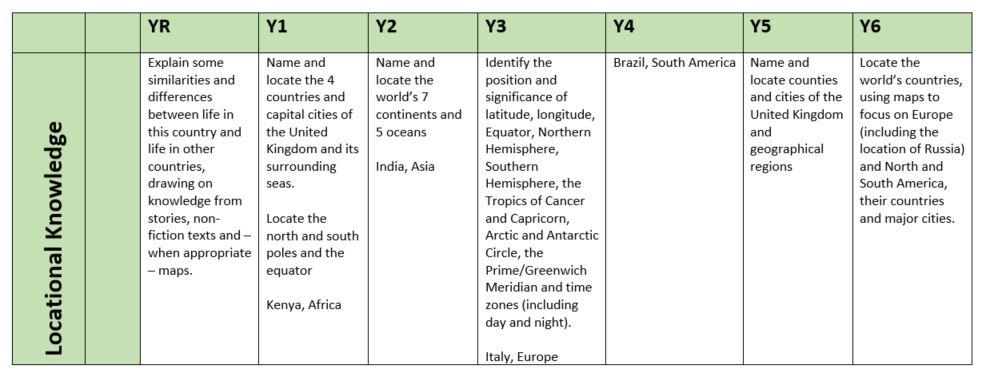
- Locational knowledge
- Place (understanding of)
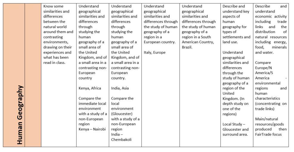
- Human Geography
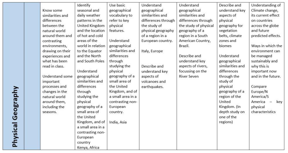
- Physical Geography
Within each strand, learning has been sequenced to show a progression from Y1 to Y6. (See progression document). Documentation ensures that teachers understand what prior learning has taken place and also what learning that children will go on to undertake.
The sequence of geography units is as follows;
|
|
Term 2 |
Term 4 |
Term 6 |
|
Year 1 |
Map Skills & Locational knowledge
|
Local study – local area – immediately surround homes and school (local estate)
|
Non-European study Kenya – Nairobi (region) Physical & human geography (compare back with local study)
|
|
Year 2 |
Map Skills & Locational knowledge
|
Local study – Gloucester
|
Non-European study India Chembakoli Physical & human geography (compare back with local study)
|
|
Year 3 |
Map Skills & Locational knowledge
|
Physical Geography Volcanoes & earthquakes |
Human Geography Italy – Lazio region |
|
Year 4 |
Map Skills & Locational knowledge
|
Physical Geography Rivers – The River Severn |
Human & Physical Geography Brazil (region) |
|
Year 5 |
Map Skills & Locational knowledge
|
Physical Geography Climate, vegetation belts and Biomes |
Human Geography Settlement & land use |
|
Year 6 |
Advanced Map Skills
|
Human & Physical Geography Climate change
|
Geographical Enquiry |
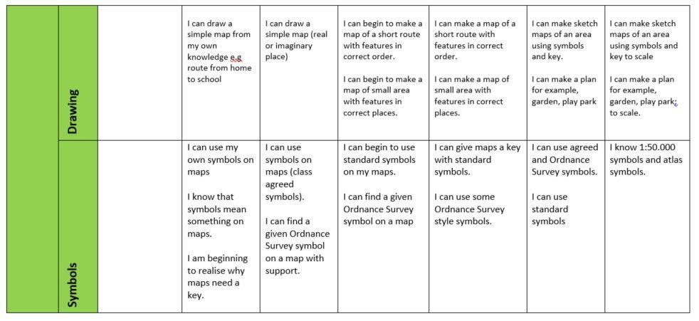
Map skills
The decision to teach a unit on ‘map skills and Locational knowledge’ in Term 2 ensures that children are taught the knowledge, skills and understanding necessary in order to apply this knowledge to other geographical units in Term 4 and 6. For example, the ability to read coordinates to pinpoint locations on a map is useful in the following unit on the River – Seven, when locations would need to be easily identified. All units in Term 4 or 6 have an element of location, with maps being used to provide an overview of the localities. The map skills learnt in Term 2 allow children to better access this information in Term 4 and 6.
Map skills are taught in a progressive way. For example the teaching of coordinates moves from simple letter/number correspondence, for example square A7 to four figure grid references, e.g 2356 and finally to six figure grid references e.g 234239. Direction is also taught in a progressive way , moving from four points on a compass to eight points. Sketch maps begin with pictorial maps, to maps which are then drawn increasingly to scale with the use of symbols developed to replace pictures in time.
Place
Children have the opportunity to study a range of different places. The initial region in Kenya has been chosen as this would link with the children’s learning in science which involves learning about animals, and later habitats. This would be relevant learning in relation to Nairobi as this links well with the physical environment.
It is particularly important that children relate this knowledge and understanding about faraway places to what they know already in their own locality. Therefore, in Y1 and Y2 a local study has been planned, moving from the very local, immediate housing and school to slightly further away, looking at Gloucester.
Children have the opportunity to study a range of different places in contrasting environments. Therefore, by the end of Year 6 they will have built up sufficient knowledge and understanding of different localities.
Physical geography
We believe that it is important that physical geography is taught in context. Therefore, when studying different global localities, both human and physical geography are taught, therefore providing an indepth understanding of a locality. In Year 4 children learn about the River Severn. It is a local and relevant river to them. The map work which takes place before then will allow them to confidently access maps and plans at a variety of scales confidently. The later unit on Brazil, which will include the Amazon Rainforest and the River Amazon, will be more meaningful as they will be able to compare and contrast their understanding of the River Severn with a major world river, much larger in scale.
In Year 3 volcanoes and earthquakes are studied. This then links to the Place unit, Lazio, a region in Italy where they can apply their knowledge of volcanoes, in particular when learning about the physical features of this region.
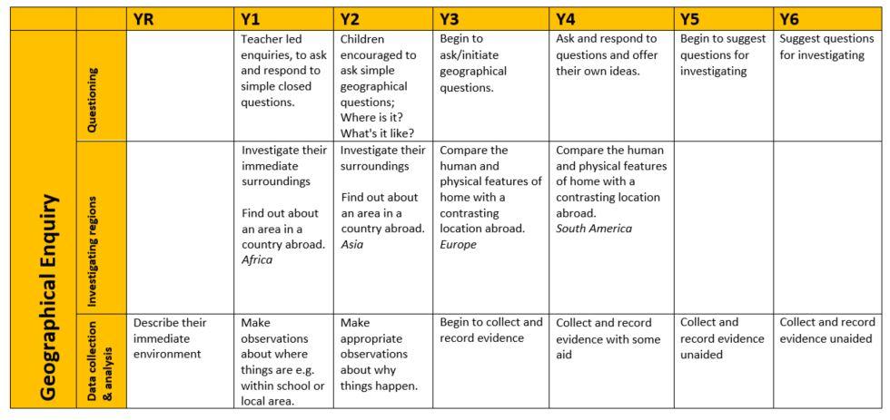
Geographical enquiry
It is expected that geographical enquiry threads through all the place and thematic units. The ability to ask the following questions is key to understanding in geography.
- What is this place?
- What is the place like?
- How is this place connected to other places?
- How is this place changing?
- What is it like to be in this place?
- How is this place similar to or different from another place?
At the end of Year 6 there is an opportunity for a ‘geographical enquiry’ unit. This will give Year 6 children the opportunity to apply the knowledge, skills and understanding learnt so far and apply it to an area of study.
Progression in substantive and disciplinary knowledge
Geographical enquiry
Map work
Locational knowledge
Human geography
Physical geography